By Mike Kline, Vermont Rivers Program Manager and
Ned Swanberg, Regional Floodplain Manager
November 8, 2018
Vermont is making substantial progress to reduce damages from its de-stabilized rivers. This is a major change from the 1970s when the state began addressing riverine hazards through the lens of flood insurance. Today there is an acknowledgment that rivers need room, and a state-wide commitment to flood resilience by focusing on the protection of river corridor and floodplain services.
New maps with river corridors to complement flood hazard areas, as well as new model bylaws have been released. Two new websites – floodtraining.vermont.gov and floodready.vermont.gov are available for community leaders. Additionally, state and municipal policies, grant criteria, and other incentive programs have become increasingly aligned reflecting a statutory commitment to flood resilience.
From 1978 through 1998 Vermont suffered damage in thirteen major flood events. This damage was not so much from being wet (inundation), but rather from being destroyed (riverine erosion). In response, in 1998, the legislature established the basis for the Rivers Program in the Agency of Natural Resources.
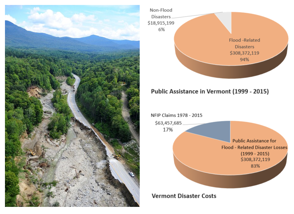
In Vermont, the most expensive type of disaster from natural causes is recorded as “riverine flooding”. Ironically, the damage is not so much from flooding but from the lack of flooding. Past policy and practice to contain flooding led to greater erosion. The costs are primarily due to the conflict between dynamic rivers and encroaching property and infrastructure. This problem is compounded by a hilly landscape with settlements in narrow valleys, a legacy of deforestation, extensive channelization for log runs, transportation networks and ex-urban sprawl.
In Vermont the power of contained high flows physically destroys roads, culverts and bridges. Private flood losses, insured through the NFIP, are less than a fifth of the overall damage. In some locations, private structures, mapped high and dry outside of high-risk flood zones, have been undermined and washed away by the power of erosion.
Early on, the Vermont Rivers Program initiated river restoration projects using natural channel design. Later it became clear that if stressors on river reaches (i.e., encroachment and channelization) were not alleviated, the active geophysical processes of rivers will overwhelm expensive spot fixes.
The data showed that 75% of assessed stream and river channels in Vermont had been pushed out of geomorphic equilibrium and were actively either incising or widening. Incised channels carry deeper and more powerfully-erosive water loads. The water often cannot flow overbank and slow down. Incised and straightened channels lose their floodplain access and hastily convey the discharge down the valley, to carve up roads and deliver more water faster, to downstream communities. Eventually the banks of deepened channels collapse, causing damage to adjacent roads and properties, and delivering excessive volumes of sediment into waters already laden with nutrient-laden stormwater.
To avoid this process of pushing rivers out of their “stable” geomorphic equilibrium, and to allow the stream channels to naturally reestablish their slowest least-erosive path down the valley, it is necessary to protect a “corridor” rather than a “setback”. The river corridor establishes an area for the channel’s dynamic meander pattern to become established and maintained. This corridor encompasses the meander belt width within the valley walls, and an adjacent area for stable banks. To minimize the vicious cycle of new encroachments, erosive damage, and loss of floodplain functions, the program began to emphasize a strategy of no adverse impact – avoiding new losses to the river system functions and services, and allowing the system to naturally reestablish, and maintain, its fluvial geomorphic equilibrium and access to its floodplains.
Since 2011, and the costly experience of Tropical Storm Irene in Vermont, the State has taken a number of steps to systematically reduce damage from excessive water. This has taken the form of a statewide initiative to prioritize plans and policies for flood resilience. The immediate post-flood period was marked by extensive collaboration among state agencies, regional planners, non-governmental organizations and municipalities. Since that time these novel relationships, required by statute, have become increasingly integrated into standard practice.
Avoiding losses to river corridor and floodplain functions is now a key strategy of the Vermont State Hazard Mitigation Plans (2013 and 2018), as well as regional and municipal plans. Significantly, the Vermont Agency of Transportation (AOT) and the Agency of Commerce and Community Development (ACCD) have worked closely with Vermont Emergency Management (VEM) and the Agency of Natural Resources (ANR) to align plans, policies, incentives, trainings and practices.
Examples include:
- The Agency of Commerce and Community Development (ACCD) worked with other agencies to support the Vermont Economic Resiliency Initiative. This initiative examined the vulnerability of economic centers statewide to flood and fluvial erosion hazards, developed robust hazard mitigation planning in six communities, and launched mitigation projects to protect downtowns, village centers, and agricultural assets.
- ACCD has also published a new Municipal Planning Manual to more extensively help communities conduct flood resiliency planning and identify hazard mitigation opportunities. Municipal Plans are now required to include a Flood Resilience Element.
- Vermont Buildings and General Services has completed an assessment of all state buildings and their vulnerability to flood and fluvial erosion damages. Mitigation plans are now under development.
- A River Corridor map for all streams and rivers in Vermont with watersheds over two square miles, is now available on the ANR Natural Resource Atlas. bit.ly/floodatlas
- Model Flood Hazard Area and River Corridor Bylaws are now available for municipalities to support no adverse impact on other properties, and to these ecosystem services. The models also address in-fill development in support of state priorities for compact development. bit.ly/model-regulations
- Community flood resilience data, planning information, and community outreach materials are now available to community leaders at two websites. floodready.vermont.gov has extensive planning information and data. floodtraining.vermont.gov features outreach and administration support for community officials including animations and video presentations of community efforts on outreach, protection and mitigation.
- The Secretary of Administration, together with VEM, AOT, and ANR honed the Vermont Emergency Relief and Assistance Fund (ERAF) into a meaningful incentive for municipal action. So far, over a third of Vermont’s 251 municipalities have adopted no adverse impact bylaws and qualify for a higher state share toward post-disaster Public Assistance (PA). tinyurl.com/erafvt
- Other Vermont state grants have also begun to provide incentives to community development (ACCD), hazard mitigation (VEM), and environmental projects (ANR) that reduce flood and fluvial erosion hazards directly or as a co-benefit.
- New and replacement bridges and culverts must now meet State standards that match the size of the opening to the natural width of the stream. All structures built to this standard survived Tropical Storm Irene. FEMA has now recognized these as eligible codes and standards under the post-disaster Public Assistance program. Vermont was the first in the nation to become eligible on this basis under FEMA Public Assistance.
- A major initiative by AOT and ANR to join river corridor and transportation corridor planning has just been completed.
- AOT and ANR have delivered a three-tiered Rivers and Roads training course for state and municipal transportation workers. The web, classroom and field-based trainings support the implementation of river management principles and practices in both emergency and non-emergency (flood) situations. Over 500 state and local personnel involved in the maintenance of roads have graduated at the Tier 2 level.
- After 2011 new statutory authorities and responsibilities for ANR were enacted. These include providing technical and regulatory assistance for channel management and instream (flood) emergency measures. From 2015-2017, state river engineers and floodplain managers have provided technical and/or regulatory assistance to over 2,500 river and floodplain encroachment (development) projects per year.
- The Vermont Flood Hazard Area and River Corridor Protection Procedures and Rules set no adverse impact standards for proposals in Flood Hazard Areas and River Corridors under state review (state projects, regulated utilities, agricultural structures, and large development proposals). The model municipal bylaws are in alignment with these standards.
- Since 2001, ANR has worked with partners to complete floodplain restoration projects in 43 Vermont municipalities and secured 90 river corridor easements, which not only restrict future river encroachments, but curtail the channelization practices that have historically led to unstable and erosive rivers during flood conditions.
These changes in Vermont, including an explicit shared goal of flood resilience and a new practice of multi-sector collaboration, represent a major shift in outlook and prospect. The pace of independent municipal action is likely to increase as communities engage in flood resilience planning, consider the ERAF incentives, and respond to deadlines around a new cycle of Flood Insurance Rate Map and bylaw updates. Damage from high flows on stressed river systems will continue. But as Vermont adapts and chooses to avoid the impacts of new encroachments, the state will invite the opportunity for a new least-erosive and least-damaging equilibrium.
Mike Kline, Vermont Rivers Program Manager and
Ned Swanberg, Regional Floodplain Manager
Nov. 2018